Dolan Springs, Mohave County, Arizona
Price: $14,800 with power
APN: 328-05-529
Acres: 1.06
Terms: $800 down payment, $206.06 per month for 72 months including 5% interest. Assumable loan, no prepayment penalty. No credit check, No reporting to any credit agency, This item will never appear on your credit report because we have no relationships with any credit agency. Full amortization, no balloon payment.
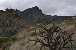
Terrain: Level with good vegetation. Electric Power to parcel. Level, no wash. Up high great views of Valley and close to foothills provide impressive mountain views. Road has not been recently graded.
Access: easy drive using Paloma Dr
Parcel Dimensions: 176.6” feet x 261.6 feet
Frontage: 176.6 fronting on North Paloma Dr
Paperwork fees/Escrow Closing fees: $0
Water Rights: attached to property and cannot be sold separately
Use Code: 0003-VL-UNDET-RURAL-SUBD
 |  |
|---|---|
 |  |
 |  |
 |  |
Legal Description: LAKE MOHAVE RANCHOS UNIT 10 LOT 551
Section 21 T26N R18W
Four Corners are located and staked with rebar
Parcel Vicinity Location:
5 miles Northwest of Dolan Springs
14.5 miles E of US93 -- the future Interstate-11 corridor
41 miles Northwest of Kingman, the County Seat, hospitals, college, all retails services
74 miles SE from Costco in Henderson NV
31 miles to Lake Mohave via Cottonwood Rd - Lake Recreation, boating, fishing, Colorado River or 39.9 miles NE to the South Cove large Boat Ramp which loads into Lake Mead and Colorado river, - Lake Recreation, boating, fishing.
65 miles to Bullhead City and Laughlin NV and the Casinos on the Colorado River
365 Day Exchange Policy -- at your option trade your land for an alternate available parcel
The future Interstate-11 corridor is shown on map
The Boulder City portion of Interstate-11 is currently under construction.
Coordinate Location: 35.619510, -114.212183
Driving Directions: From the Intersection of US93, future Interstate-11, and Pierce Ferry Road, travel NW on Pierce Ferry Rd for 9.5 miles. Turn right (East) onto Seventeenth Street and travel 2 miles to Paloma. Turn right (South) onto Paloma for one mile. Parcel is on right side of Paloma (West). The parcel is located 200 feet North of 15th St. and Federal BLM Wilderness area begins on the South side of Fifteenth. The Mount Tipton Wilderness is a 30,760-acre wilderness area and comprises the north portion of the Cerbat Mountains.
Area: 48.06 mi². There are 233 Wilderness areas managed by BLM in Western States. Recreational uses in wilderness include activities such as hunting, fishing, hiking, horseback riding, backpacking, camping, nature study, photography, and climbing. Bicycles and other forms of mechanical transport are not allowed in Wilderness Areas, since they are prohibited by the Wilderness Act.